Trail Walking Les Arcs-sur-Argens - Les Arcs-Sommet des Terriers 0 - Photo
 Sugg
Sugg

User

© OpenStreetMap contributors
Length
Length
17.2 km
Max alt
Max alt
335 m
Uphill gradient
Uphill gradient
566 m
Km-Effort
Km-Effort  
25 km
Min alt
Min alt
28 m
Downhill gradient
Downhill gradient
567 m
Boucle
Boucle
Yes
Creation date :
2019-03-22 16:59:33.834
Updated on :
2019-03-22 16:59:33.91

(0 Reviews)

Walking
Walking
5h36
Difficulty : Difficult

Scan this QR Code to open this trail in the SityTrail application

FREE GPS app for hiking

Logo SityTrail SityTrail

IGN / Geographical institutes

Download SityTrail from the App Store Download SityTrail from Google Play

Logo SityTrail SityTrail Plus

The world is yours!

Download SityTrail from the App Store Download SityTrail from Google Play Download SityTrail on Huawei AppGallery

About

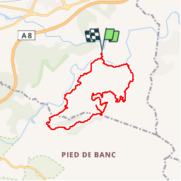
Trail Walking of 17.2 km to be discovered at Provence-Alpes-Côte d'Azur, Var, Les Arcs-sur-Argens. This trail is proposed by Sugg.

Description

Rando réelle du 02-12-15 avec RF.
Quelques difficultés, en particulier au Sud-Ouest, la remontée en 123 ( citerne ) est particulièrement raide ( pour des seniors ).
Très beau et riche parcours, voir ici : http://www.mairie-les-arcs-sur-argens.fr/associations-culture/tourisme/patrimoine.html
Ce parcours sera a nouveau effectué mais dans une version plus simple.

Elevation profile

Positioning

Country:
France
Region :
Provence-Alpes-Côte d'Azur
Department/Province :
Var
Municipality :
Les Arcs-sur-Argens
Location:
Unknown
Start:(UTM)
298517 ; 4812084 (32T) N.


Close
My subscriptions